
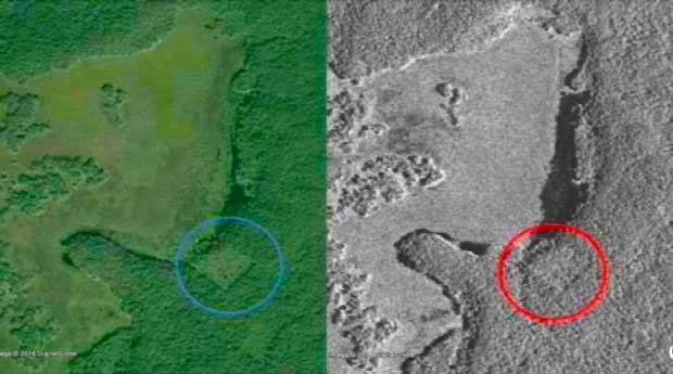
In 2016, a 15-year-old from Quebec made headlines with a bold claim: he had pinpointed an undiscovered Maya city using star maps and satellite imagery. William Gadoury proposed the existence of Kʼàakʼ Chiʼ, translating to “Mouth of Fire,” deep in the jungles of Campeche in southern Mexico.
The remote prediction generated immediate attention, utilizing data from the Canadian Space Agency, NASA, and JAXA. However, as Mayanist scholars reviewed the exact coordinates, the search for the ancient site took a completely different direction.
Aligning Constellations with the Yucatán Peninsula
Gadoury developed his theory after reading about 2012 Maya doomsday prophecies. He questioned why the civilization built cities on marginal lands or mountains instead of near rivers. Knowing the Maya tracked the stars, he overlaid a star map onto the Yucatán Peninsula.
Gadoury matched 117 known archaeological sites with the positions of stars in 22 supposed constellations. He then looked at a 23rd constellation containing three stars. Finding only two corresponding sites on the ground, he predicted a third settlement must exist at the exact location of the third star.
Space Agency Data and Academic Pushback
Using satellite imagery, Gadoury identified geometric anomalies at his predicted coordinates. But academic pushback was immediate. Mexico’s National Institute of Anthropology and History stated they were not considering the find, citing a lack of scientific basis.

Mayanist David Stuart identified the satellite anomaly as an old cornfield, or milpa, categorizing the remote prediction as junk science. Geoffrey Braswell of the University of California concurred, stating the imagery showed either an abandoned milpa or an active marijuana field, definitely not a pyramid.
The Density of Maya Settlements
Experts pointed out massive flaws in the astronomical hypothesis. Nikolai Grube of the University of Bonn noted that the 117 sites Gadoury mapped were constructed decades or centuries apart, making unified urban planning impossible. Anthropologist Anthony Aveni clarified that the arrangement of the 13 Maya zodiacal constellations remains highly debated.
Furthermore, Francisco Estrada-Belli explained that the Yucatán region is so densely packed with undiscovered archaeological ruins that placing a finger anywhere on the map gives a high probability of hitting a settlement.
Ground Verification in Campeche
Archaeologists noted that the specific area in Campeche had been extensively explored since the 1930s. The coordinates were positioned near the already excavated ruins of Uxul.
The debate finally concluded in the summer of 2021. During a reconnaissance trip into the Calakmul Biosphere, Jerald Ek traveled to the exact location east of Laguna La Amapola. Field verification proved that there were no significant archaeological structures at the coordinates, confirming that Kʼàakʼ Chiʼ does not exist.